


We began our journey into the great unknown, along the 1,240km/770 mile long ‘Highway 7’ (referred to as the Carretera Austral), from Puerto Montt to Villa O'Higgins, through remote Chilean Patagonia. With the little information we could find via a ‘Chile Backpackers’ facebook group, we discovered there was a chance to take 1 bus per day from the nearby port town of Puerto Montt, 240km down to our first destination, Chaitén. It supposedly left at 7am, and with no way to reserve a ticket in advance or communicate with the company, the advice was to turn up at the bus terminal as early as possible to try to get a seat. This was a ‘bimodal’ journey, meaning we would take the 4 bus journeys and 3 ferry trips all on the same bus. While it is technically a highway, the road is connected with boats to cross fjords in stunning national parks impassable by road. What an adventure!
The earliest bus from Puerto Varas to the Puerto Montt bus terminal was too close for comfort, so we took an Uber (couldn’t believe they operated here!) early in the morning to arrive at 6am on the dot. Our early start paid off as we arrived at the station just as the main gates opened, and managed to be at the front of the queue to secure 2 seats. While we were surprised at the time, apparently it was quite typical that the 2 seats we chose on the bus had actually been reserved by someone else (we still have no idea how!) and we were relegated to the back of the bus. We were still grateful to be on our way, and heading south.
We met another cool gringo while on the bus who was an American named Steve. He had recently completed his Masters in Glaciology and had been most recently based out of Norway. Steve was in a similar situation to us - despite his best efforts, he didn’t really have much of a plan and didn’t know where he was sleeping that night! We really enjoyed chatting to Steve and learning more about his field of work, and his journey to Patagonia.
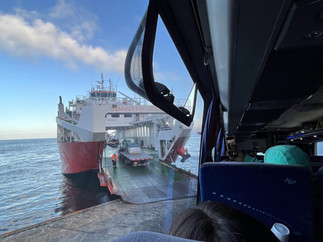
We were instantly reminded of New Zealand along the journey. Lush green fernery lined the windy roads, as we passed small wooden cabins, vast subtropical forests and hugged the rocky coastline. Before we knew it, we were driving onto the first vehicular ferry, where we remained seated on the bus for the short cruise, before another hour on the road. The second ferry was 3 hours, and we were happy to be able to get out on the deck, stretch our legs and enjoy the beautiful day. We were so lucky with the weather, it was a clear and calm day as we cruised through the fjords and thought back to our past experiences in Milford and Doubtful Sounds. It sure did remind us of home!
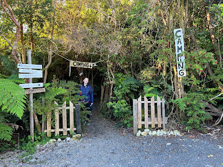
As the journey continued, more and more backpackers were picked up by the bus from various trailheads on the highway, and it became standing room only. 10 hours after departing Puerto Montt, (1 hour bus, 20 minute ferry, 1 hour bus, 3 hours ferry, 20 minute bus, 40 minute ferry, 2 hours bus, extra time waiting to board ferries), we rolled into Chaitén just before 5pm. It had been an epic day, but we were exhausted and sore from being cramped in the bus for most of the day. With the excellent weather, we decided to camp for the night, and found a local campsite among lovely greenery. We bid farewell to Steve, and while we didn’t exchange details, we had a funny feeling we might be bumping into him again soon.
Our initial intention was to try to get down to an area called El Amarillo that night and camp in the nearby Pumalin National Park, but we soon discovered that even though it was peak season, there were no more buses scheduled for the evening, and hitchhiking with all of our gear would be difficult this late in the day! We realised it was going to be challenging without a car down here and we weren’t quite packed light enough to be up for regular hiking with all of our belongings. We visited the local tourism office (in a local's house) to find out the next scheduled bus, and decided to buy a ticket south to the next town of Puyuhuapi (pronounced Poo-you-wah-pee) for the following evening. While we didn’t have any firm future reservations until 28 February and it was only 31 January, there were many places on our Carretera Austral bucket list, and we decided to keep moving.
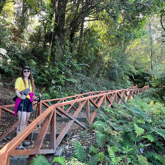
Chaitén gave us total West Coast, South Island of New Zealand vibes. We were greeted with super rugged scenery, vast open spaces and tall mountains surrounding a small town bordering on the fjords. The town of Chaitén was almost entirely wiped out by the El Chaitén volcanic eruption in 2008, and this small community was still slowly rebuilding. We found out the reason why so much of the scenery looked similar to New Zealand was because this region of Chile was at a similar latitude on the globe, and the 2 countries (plus Tasmania in Australia) are the only places in the world home to the Nothofagus family of tree, which is why it all felt so familiar. The main attraction in Chaitén was a hike up the side of the volcano, but having recently watched documentaries on the tragic volcanic tourism events of Whakaari / White Island in New Zealand, we weren’t too keen to head up this active volcano. So, we decided to take it easy with a couple of short walks around town, joined by a puppy friend who led the way to the river and estuary. We enjoyed the scenery and the chilled pace, and whilst we wished we had time (and a vehicle) to go into Pumalin National Park, it was time to take the bus down to Puyuhuapi.
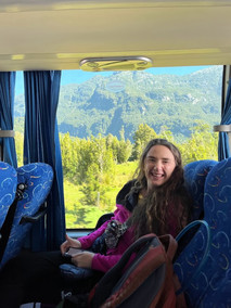
During our month along the Carretera Austral, we were constantly reflecting on the best mode of transport for this unique journey - would it be easier to have your own vehicle, take the bus, or brave it on a bicycle? There were advantages and disadvantages to all of them, but in this moment we were enjoying both the views from our window seats on the bus because it meant not having to focus on driving/biking along the mostly gravel road (and not having to come across this bus driving towards us in a rental car!!). It was a very bumpy ride, and we often worried if the bus might just rattle apart, but we did manage to make it in one piece. Jelley was once again making friends with the Dramamine motion sickness pills which were doing the trick. We passed a couple of very small villages along the way and we felt a million miles away from the bustle of Santiago. What was meant to be a short 2 hour journey turned into a 4 hour slog, and it was a relief to arrive in the quaint town of Puyuhuapi.
Puyuhuapi reminded us a lot of Havelock, or another tiny port town in the Marlborough Sounds of New Zealand (sensing a theme here??), situated at the end of a long channel deep in the fjords. Although very small, it had a much more established vibe than Chaiten and we instantly loved it. It was time for a night off camping and cooking already (lol), and we learnt the hard way that a ‘un doble cama’ in Spanish was 2 single beds rather than '1 double bed' as the translation would appear. We didn’t mind at all, and enjoyed being horizontal with a pillow again. Our hosts Don & Rosa immediately knew what we were there for, and while we didn’t speak the same language, they quickly helped us arrange a transfer for the morning to the nearby Queulat National Park.
After a cooked breakfast, we were picked up by a local in a van to drive us 30 minutes down the gravel highway to the national park. The entrance ticket system was somewhat comical, and reminded us of our Tayrona national park entrance experience in Colombia, which involved hours of queuing and buying multiple nonsensical tickets. Before we could even leave town to drive to the park, we were required to to reserve 'tickets' with the CONAF website (Chile's DOC/NPS equivalent). This reservation then generated a digital QR code which we had to save offline to our phones because there is no cellphone reception at the park. Once at the park entrance, we then had to line up at the rangers office, show our QR codes and then pay for the actual entry tickets which was a handwritten piece of paper. We couldn't help but wonder "why can't the online reservation be your entrance ticket?" Had this happened later in our travels through Chile we probably wouldn’t have blinked twice at this series of events, but at the time we felt very confused.
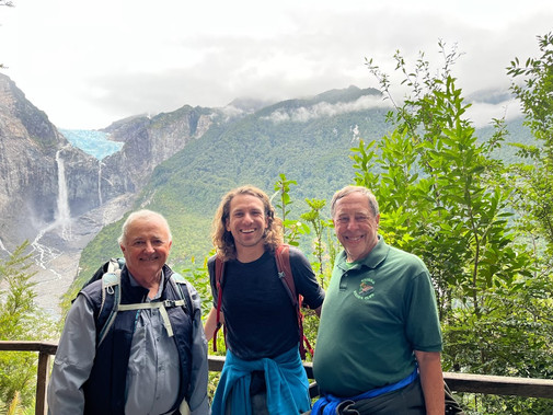
It was our first overcast day in Chile and we went in with low expectations of seeing the Hanging Glacier in Queulat National Park, thinking it may be covered in clouds. However, we were in luck and got a wonderful view of our first glacier of the trip! The Hanging Glacier gained its name due to it precariously appearing to hang from the rocks above the valley carved out by the glacier many years ago. We took 4 different trails around the park, with the longest bringing us closest to the glacier (still quite far away!). As we approached, we heard the thundering noise of a chunk of the glacier falling off and crashing into the valley below. It was a shocking sound, and just a small taste of our glacial journey still to come (pun intended).
There was a group of Americans hiking up to the lookout and we noticed one of them had an ‘Orinda hiking club’ shirt on. Coincidentally, Luke’s family live in the neighbouring suburb to Orinda in the Bay Area back in California. It felt like such a small world chatting to them. It was also impressive to hear how the group were on a 3 week adventure in Patagonia and had around 30 other international trips planned for the club this year! We promised to introduce Luke’s mom to them in hopes that she might consider joining the club.
On our descent, we stumbled upon a familiar face. It turned out Steve (the American Glaciologist from our ferry & bus journey from Puerto Montt) had decided on the same hike that day! We exchanged contact details and discussed plans for the coming week. We were blessed with a unique upcoming 5 day weather window (a rarity in Patagonia) and wanted to make the most of it. We began formulating an ambitious plan to hike the 4 day Cerro Castillo trail (300km south of Puyuhuapi). After a quick logistics planning session figuring out buses, how to get provisions for the hike and where to store the rest of our gear, we locked in our next stop on the journey.
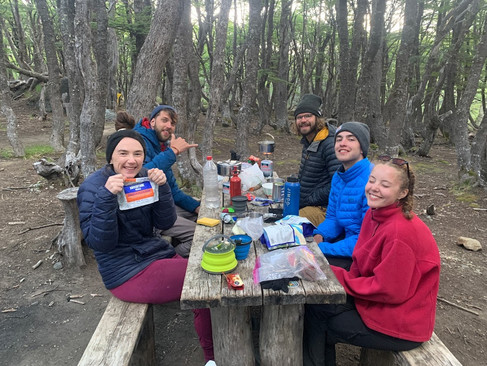
It was another early start, rising at 5.30am to catch the 6am bus from Puyuhuapi to Coyhaique (pronounced "coy-yah-key"). Again, what Google suggests is a 2.5 hour drive took 5+ hours. We did feel surprisingly good when we arrived around 11am after another stunning scenic ride. We had found a nice hostel in town, which unfortunately didn’t have availability at such late notice, but agreed to store our excess luggage (electronics and nicer clothes) if we stayed with them post-hike. With lighter loads on our backs, we ventured into the town centre to meet Steve at the huge ‘Unimarc’ supermarket to stock up on food for the hike. We had heard horror stories about queues of 60-120 minutes, as it was the only large store in the region. Jelley got lucky with self-checkout, but Steve took about an hour between self-checkout machine issues and eventually needing to join the long line. Shopping for food added to the growing list of challenges we faced travelling the Carretera Austral.
It was a chilled afternoon, as we tried to find a map for our upcoming hike (without luck) and did some quick research while we had cellphone reception. Accommodation was more expensive in Coyhaique, the capital city of the Aysen region. Since we knew we had a really nice home to look forward to post-hike, we decided to camp at a cute spot just outside of town for the night. We’d hoped to hitch a ride for the 3.8km to the bus station for our 8am departure, but the roads were quiet, and the 1 Uber showing on the app was non-responsive, so we got some extra steps in for the day by walking down the highway. We met up with Steve, found our bus and hit the road 1 hour south to Las Horquetas, where our 4 day hike through Cerro Castillo National Park would begin.
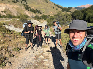
A young American couple, Lydia and Kris, who were on their gap year from high school (so cool!) arrived on the roadside from a different bus at the same time, and we joined forces to make a squad to hike the trail together. A short distance in, we came across the rangers office to buy our permit, and received a surprisingly informative safety briefing for the trail. The process was a lot easier and more organised than Queulat National Park, and we even received an informative paper map, our first since arriving in Chile.
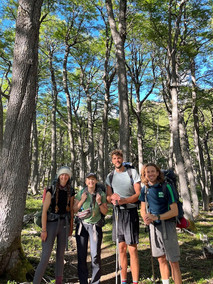
It was scorching hot with not a cloud in the sky. Luke had lost around his 6th pair of sunglasses on our travels during the packdown in the dark earlier in the day, but luckily the majority of this long, flat trail was shaded through trees. It was a lovely, relaxed nature trail, mostly through beech forest. We arrived at the first possible campsite around 3pm, but with so many daylight hours left and a harder day ahead for day 2, we collectively decided to continue onto the next site at Rio Turbios. Jenny joined our tribe - she was a rare Carretera Austral northbound traveller, and we were filled with questions on what lay ahead on the road for the rest of us. It was quieter than expected, given the number of names we had seen in the intentions book at the rangers hut and other travellers we had met in the days prior intending on hiking at a similar time.

It was a relaxed first day, and good to be moving our legs again. Whilst we had completed multi-day hikes in NZ, usually we had the luxury of staying in DOC huts each night, and not having to carry the weight of a tent and extra sleeping equipment. This was a great trial run for the 8 day hike we had booked for the next month down in Torres del Paine National Park. It felt like a long way away but we knew we needed to start training for it. It was a peaceful night’s sleep at a chilled spot in the trees, with the exception of a downpour around 4.30am, when we quickly grabbed our clothes and food we’d left outside. We were grateful for our rain-fly on the tent, knowing Steve was further down in the forest in his tiny $20 non-waterproof tent. ‘I slept like I was in a $20 tent’ - quote from Steve.
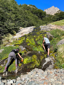
Our intended 8am departure became 8.40am, as we climbed out of the forest up a trail steeper than the day before. We emerged from the bushline, looking up in awe of the El Peñon pass ahead of us we would be crossing today. Again, we couldn’t believe our luck with a bluebird day, and the winds were calm for us as we climbed the rocky pass. We looked behind us and could see views stretching along the valley below to our campsite from the night before. As we climbed up loose rocks to the top of the pass, we came across a small patch of snow to cross - a novelty in the summer!
After turning the corner to commence a steep descent, we were greeted by a stunning vista, featuring countless waterfalls coming down from a glacier. The perfect place for a lunch stop! We met yet another American hiker here, Justin from Colorado, who was like a goat in the mountains and after a quick chat, we couldn't keep up with his pace! We reunited at camp later and he became the 7th member of our Cerro Castillo squad. We took care as we hiked down the steep shingle rocks, continuing through the forest, across a couple of small rivers and before we knew it, arrived at our next campsite for the night! It was so nice to have diversity in the landscapes with every day being different on this track.
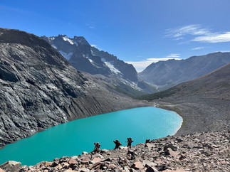
After some campsite chill time and a couple of snacks, we decided to head up the short trail to a nearby lake at the base of a glacier, Laguna Verde. Steve and Jenny were having a nap, and we hadn’t seen Lydia and Kris yet, so the 2 of us ventured up alone. It was a bit of a scramble, but such a freeing feeling without the weight of our packs. The lake was 100% worth the extra steps. We loved sitting by the glacial lake, watching the icebergs float by and hearing parts of the glacier fall off in the distance.
On Day 3, we left much closer to our intended 8am departure time, leaving camp at 8.07am after a good night’s sleep. Our fellow hikers were a little further behind in their camp pack-down, so we set off alone through the beech forest. The end goal was Camp Neozelandes (translating to New Zealanders!) but the journey was scheduled to be even more beautiful than the destination today.
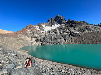
We were visiting Laguna Cerro Castillo, the most iconic spot on the hike and the location the national park is named after. Cerro Castillo, translating literally to 'Castle Hill', was the name of the rock formations sticking up like a pointy fortress looking down over the park, and on a clear day, visible from most spots on the trail. We arrived early, around 9.15am, and had the lake to ourselves. It was perfectly still, the Patagonian winds hadn’t yet started for the day. It was incredible to see the crystal clear reflections of the castle on the water. As the wind gradually picked up, the sun rose higher in the sky and we continued our journey, the still lake became a brilliant bright blue, with slight ripples from the wind running across the lake surface.
Distracted by the scenery, we took a wrong turn, resulting in an ominous vertical scramble up the side of the lake to connect back to the trail again. We tried to warn off Lydia and Kris who we could see as specks in the distance below, but our pole swinging encouraged them to continue upwards. Once we reached the trail, it ran along a ridge line looking over the stunning lake and another neighbouring glacier hanging above. We felt like we were on the top of the world.

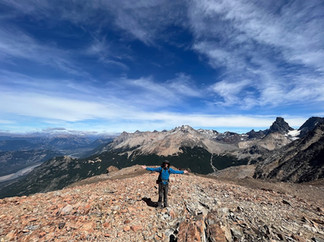
Our hiking buddies caught up with us (we had started to get worried; turned out they also got lost a little earlier and nearly conquered another mountain pass in the wrong direction!), and we continued together along the rocky terrain. Near the top of the mountain pass, the landscape opened up to 360 degree views of the valley and rivers below, with the glacier and Cerro Castillo behind us. We could even identify the Carretera Austral road, far below, snaking its way through the incredible landscape. It was another epic spot for lunch, and we were again filled with gratitude to be sharing this experience in such brilliant weather and lovely company. It was especially handy having glaciologist Steve with us, who gave us another lesson on glaciers and rocks, in the most beautiful classroom in the world.
It was another long, challenging 800m descent over loose rocks, requiring acute attention. We passed another more populated campsite, where hikers completing just a section of the trail from the other end were staying, before continuing to the 'New Zealanders' campsite. It was neat once we got there, with just 9 of us camping out, and we had become quite the hiking tribe by this stage. It was our last night together, and while we still hadn’t figured out how to use Lydia’s 'whisperlite' cooker, we had really enjoyed our time getting to know everyone and creating these shared memories.
We did meet a couple who were packing up their tent and had crossed the same mountain pass the day before. They had experienced self-described ‘life-threatening winds’, and we felt like we’d struck the jackpot with such a calm day. We were glad to have continued to Neozelandes camp and not stopped at the more populated camp earlier, as it felt very remote, and was a short distance from a gorgeous open meadow. We were soaking in the last of the sun rays, and feeling so satiated with the journey that we didn’t feel the need to continue for another 5km roundtrip from the camp up to another laguna/lake.
The final day was all downhill, as we descended from the campsite to exit the national park in 2 hours, with another 2 hours along a gravel road to the town of Villa Cerro Castillo where we would (hopefully) be catching a bus from. The gravel road was long and arduous with the sun beating down on our sore bodies, but the motivation of a shower, clean clothes and a cold drink kept us moving quickly. We were stoked when Luke successfully hailed down a farmer who let us jump in the back of the truck and hitch a ride for the final 2km into town. Poor Steve continued on and missed the ride, but joined us by foot not too long after. Sadly, this was the last we saw of Jelley’s hiking poles as Luke accidently left them in the boot (‘trunk’ for the Americans out there). While disappointing, it was the best possible time to lose them really as we were returning to Coyhaique, with the best chance of finding replacements.
We hailed down a minibus on the highway, and backtracked a little way back up the Carretera Austral to Coyhaique. We were so glad to have completed this 53km trek over 4 days, but immediately fell asleep in the minibus, with dreams of being reunited with our clean clothes and the treat of 2 nights in a ‘hostel’. Huella Hostel was more like a boutique hotel with incredible amenities, the comfiest beds, a warm, welcoming host and it was an all-around fantastic place to stay. We were sore from the end of the hike, tired, hungry and dirty. After a well-deserved shower, quick laundry run and short walk into town, we treated ourselves to some great Mexican food and a final beer with Steve. We were sure we’d run into him again, and it had been awesome sharing such a great part of our Carretera Austral journey together so far. Luke spent much of the hike convincing Steve that his next destination should be New Zealand on the working holiday visa - it was an easy sell and we look forward to welcoming him in the near future!
Coyhaique was the perfect place to rest and recover, and we had to plan our next destination. Unfortunately, heavy rain and wind was forecast for the next 7-10 days, and most of the destinations on our trip involved outdoor activities. We were a little stuck on whether to boost it much further south, or still try to take in the sights we’d saved on our Google Maps and hope for a weather window to enjoy them. We decided to take the gamble and booked a bus to travel another 220km down to the small tourist town of Puerto Rio Tranquilo, home to the famous marble caves on Lake General Carrera.
We were excited at the adventures that lay ahead, and almost happy to be sitting on a bus again for an unknown travel time to continue exploring this untouched paradise.
Until then,

- A Kiwi and A Cali
P.S. Don’t forget to write your name if you leave a comment!

Wow! Just incredible! I so enjoyed learning about your adventures in the Chilean Patagonia! Now I need to google the 2008 Volcan by Chaiten, and much more! All I can say is WOW!!!! Thanks for sharing!!! Love ya, Mom Luella